Fuel Reduction & Defensible Space
Free Fuel Reduction Work for 2022 Winter Storm Recovery
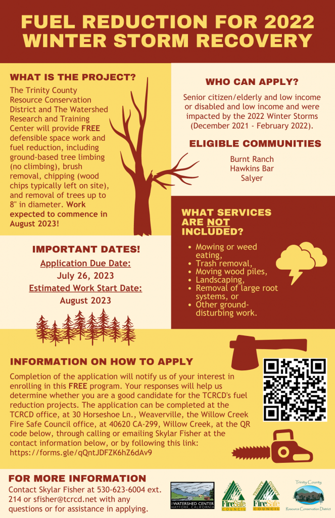
The Trinity County Resource Conservation District and The Watershed Research and Training Center will provide FREE defensible space work and fuel reduction, including ground-based tree limbing (no climbing), brush removal, chipping (wood chips typically left on site), and removal of trees up to 8″ in diameter. Work expected to commence in August 2023!
Services not provided include:
- Mowing or weed eating,
- Trash removal,
- Moving wood piles,
- Landscaping,
- Removal of large root systems, or
- Other ground-disturbing work.
Eligibility Requirements
The objective of this project is to serve residents who meet the criteria for senior citizen/elderly and low income or disabled and low income and were impacted by the 2022 Winter Storms (December 2021 – February 2022). This project targets the Burnt Ranch, Hawkins Bar, and Salyer communities.
How to Apply
Completion of the application will notify us of your interest in enrolling in this FREE program. Your responses will help us determine whether you are a good candidate for the TCRCD’s fuel reduction projects. The application can be completed at the TCRCD office, at 30 Horseshoe Ln., Weaverville, through calling or emailing Skylar Fisher at the contact information below, or by following the link below.
For More Information Contact Skylar Fisher at 530-623-6004 ext. 214 or sfisher@tcrcd.net with any questions or for assistance in applying.
Fuel Reduction Interest Form:
Salyer, Burnt Ranch, and Hawkins Bar Storm Recovery: Fuel Reduction Interest Form
Fuel Reduction in Trinity County
Trinity County Fire Simulations – Pre & Post Fuel Treatment
Hayfork Fire Simulation – Pre and Post Fuel Treatment
Open Canopy Production produced this model of Hayfork based off the model produced last year for Hayfork, with a wildfire starting in the agricultural fields west of Hayfork. Then projects identified in the Trinity County Community Wildfire Protection Plan community meetings were added into the model. Projects include roadside shaded fuels breaks and defensible space work. Check out how the projects change the direction of spread and rate of spread of the wildfire.
This model is does not take into account suppression efforts which also impact the progression of a wildfire. This is only a model and not to be taken as fact. This collaboration was made possible by the Fire Adapted Communities Learning Network.
Weaverville Fire Simulation – Pre and Post Fuel Treatment
Open Canopy Production produced this model based an escaped campfire. Then projects identified in the Trinity County Community Wildfire Protection Plan community meetings were added into the model, specifically shaded fuel breaks and defensible space. Check out how the projects change the direction of spread and rate of spread of the wildfire.
This model is does not take into account suppression efforts which also impact the progression of a wildfire. This is only a model and not to be taken as fact. This collaboration was made possible by the Fire Adapted Communities Learning Network.
Hawkins Bar Fire Simulation – Pre and Post Fuel Treatment
Open Canopy Production produced this model based off a spark from State Route 299 starting a fire along the road. Then projects identified in the Trinity County Community Wildfire Protection Plan community meetings were added into the model. Check out how the projects change the direction of spread and rate of spread of the wildfire.
This model is does not take into account suppression efforts which also impact the progression of a wildfire. This is only a model and not to be taken as fact. This collaboration was made possible by the Fire Adapted Communities Learning Network.
Trinity Center Fire Simulation – Pre and Post Fuel Treatment
Open Canopy Production produced this model based an escaped campfire. Then projects identified in the Trinity County Community Wildfire Protection Plan community meetings were added into the model, specifically shaded fuel breaks and defensible space. Check out how the projects change the direction of spread and rate of spread of the wildfire.
This model is does not take into account suppression efforts which also impact the progression of a wildfire. This is only a model and not to be taken as fact. This collaboration was made possible by the Fire Adapted Communities Learning Network.
Douglas City Fire Simulation – Pre and Post Fuel Treatment
Open Canopy Production produced this model based an escaped campfire. Then projects identified in the Trinity County Community Wildfire Protection Plan community meetings were added into the model, specifically shaded fuel breaks and defensible space. Check out how the projects change the direction of spread and rate of spread of the wildfire.
This model is does not take into account suppression efforts which also impact the progression of a wildfire. This is only a model and not to be taken as fact. This collaboration was made possible by the Fire Adapted Communities Learning Network.
Big Bar Simulation – Pre and Post Fuel Treatment
Open Canopy Production produced this model based a roadside ignition along Hwy 299. Then projects identified in the Trinity County Community Wildfire Protection Plan community meetings were added into the model, specifically shaded fuel breaks and defensible space. Check out how the projects change the direction of spread and rate of spread of the wildfire.
This model is does not take into account suppression efforts which also impact the progression of a wildfire. This is only a model and not to be taken as fact. This collaboration was made possible by the Fire Adapted Communities Learning Network.
Junction City Simulation – Pre and Post Fuel Treatment
Open Canopy Production produced this model based a fire starting say around 6am (so down canyon winds) along Dutch Creek Rd near the Evans Bar River Access. Then projects identified in the Trinity County Community Wildfire Protection Plan community meetings were added into the model, specifically shaded fuel breaks and defensible space. Check out how the projects change the direction of spread and rate of spread of the wildfire.
This model is does not take into account suppression efforts which also impact the progression of a wildfire. This is only a model and not to be taken as fact. This collaboration was made possible by the Fire Adapted Communities Learning Network.
Lewiston Simulation – Pre and Post Fuel Treatment
Open Canopy Production produced this model based on a roadside ignition on Trinity Dam Blvd. Then projects identified in the Trinity County Community Wildfire Protection Plan community meetings were added into the model, specifically shaded fuel breaks and defensible space. Check out how the projects change the direction of spread and rate of spread of the wildfire.
This model is does not take into account suppression efforts which also impact the progression of a wildfire. This is only a model and not to be taken as fact. This collaboration was made possible by the Fire Adapted Communities Learning Network.
Trinity Lake / Covington Mill Simulation – Pre and Post Fuel Treatment
Open Canopy Production produced this model based on a roadside ignition on HWY 3. Then projects identified in the Trinity County Community Wildfire Protection Plan community meetings were added into the model, specifically shaded fuel breaks and defensible space. Check out how the projects change the direction of spread and rate of spread of the wildfire.
This model is does not take into account suppression efforts which also impact the progression of a wildfire. This is only a model and not to be taken as fact. This collaboration was made possible by the Fire Adapted Communities Learning Network.
Ruth Lake Simulation – Pre and Post Fuel Treatment
Open Canopy Production produced this model based on a roadside ignition on Lower Mad River Road. Then projects identified in the Trinity County Community Wildfire Protection Plan community meetings were added into the model, specifically shaded fuel breaks and defensible space. Check out how the projects change the direction of spread and rate of spread of the wildfire.
This model is does not take into account suppression efforts which also impact the progression of a wildfire. This is only a model and not to be taken as fact. This collaboration was made possible by the Fire Adapted Communities Learning Network.